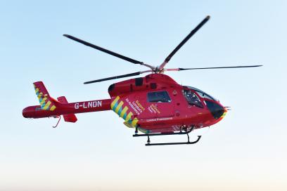
The London Loop Part 1 : Teddington to Hatton Cross
Time for another quest, the scope limited in the current COVID-19 world, so no Globe Trotting hunting Concorde, instead a longish walk.
I have been walking a lot since COVID has become part of our lives, usually in the evening around the neighbourhood, my Fitbit tells me that since March that’s an average of 21,000 steps per day !
Much as I love this part of South West London, I wanted a challenge and was vaguely away of the London Loop, a walking route around London of some 150 Miles ( 242 km) which happens to pass through Bushy Park very close to my home in Teddington.
The only real question was which way… Clockwise of course!
The Beginning and hopefully the end – Chestnut Avenue, Bushy Park
The route is signed although not very well in places and although the trusty OS Explorer map can be vague in places, it really is required – it may not be hiking up Snowdon but without one you will get lost !
1:25,000 Ordnance Survey – Old School but very necessary!
Today was Part 1 an easy 10 miles or so from the starting line of the Chestnut Avenue in Bushy Park, following the River Crane to Hatton Cross close to Heathrow Airport, actually remarkably rural as you case see from the pictures below..
Interesting sight on this part of the route is the Shot Tower in Crane Park, built in 1826 to manufacture lead shot.
Crane Park Shot Tower
Essentially a lighthouse with a heating chamber rather than a light at the top. Lead was heated until molten, then poured through a copper sieve. The size of the shot determined by the size of the holes in the sieve. As the drops of molten lead fell through the air surface tension formed them into spherical balls. At the bottom of the tower the lead shot was caught in a water-filled basin.
Bloomberg reports the latest rumours surrounding the upcoming iPhone launch, including such Geo technologies as LIDAR expected to feature in at least some of the new devices this Autumn.
The extent to which such previously specialised and complex technologies are reaching the mass market should not come as a surprise, after-all GPS receivers were once very specialised. As soon as a consumer value was identified however, mass market production and simplification reduced the price of these features considerably, and today they provide much of the smart in smartphones!
However the most interesting part of the report for me is almost a footnote, Apple will introduce a “Find my Remote” capability to the next generation Apple TV.
In the crazy days of Where 2.0 and the maximum inflection point for Location Based Services (LBS) we used to quote that one of the most common phases uttered on phone calls was “Where are you?”, thus we argued there was a huge opportunity for friend finding applications – well that did not quite work out, however when did you last ask at home… “Where is the TV remote?” while searching under the sofa cushions…
Where is the TV remote ?
Unlike friend finding there are no privacy implications of finding your own stuff in your own home.
This is a perfect example of Ambient Location working at the personal scale, the application of traditional geospatial technology over the range of a few metres often having the users own location as the origin of a local private coordinate system.
It may be argued that we are still only in the early days of the “Internet of Things” where the networked devices we own at home (or work – is there a difference these days?) both provide relevant information to us and modify their behaviour based on both environmental factors and the proximity of people to them.
I get the feeling I’m still very much the “early adopter” with my Nest smoke detectors sensing when nobody is at home to switch off the heating or having my Hue controlled lights automatically turn on when my video door bell recognises I’m returning home..
This is all still rather complex to set up and, if I’m honest, rather flakey in operation..
But… there is another innovation which the “Find my Remote” use case also demonstrates that may make this all much more mainstream.
Coming to a surface near you soon…
Surface computing is another term beloved by technologists which covers the development of voice based assistants and other personal technology such as home electronic displays which are becoming alternative “surfaces” which we use to interact with the internet and with cloud based services.
“Alexa, re-order AA batteries”, “Hey Google, Join my meeting”, and soon “Siri, where is my remote” are phrases becoming common in our homes and make use of the surface interfaces to home automation services – and of course many of these surfaces rely on an explicit knowledge of location, at least within the logical framework of our homes.
If I’m in the Kitchen, I just have to ask to “Switch on the lights”, there is an explicit knowledge that since the Home Hub in the kitchen picked up my voice, the lights I’m requesting switched on are those in the kitchen..
The logical map of my home?
This understanding of our homes from a spatial perspective is still rather limited, we don’t for example usually have an understanding of the topological connections between rooms but that will come… perhaps from devices equipped with LIDAR!
The “Parsons Test” of IoT ?
In the past I have offered the simple use case of
“Hello Computer, are my keys upstairs?”
as a test case for demonstrating a useful application of combined IoT / surface computing, seems we are getting close to passing the test.
When you expect a surface computing interface…
Of course we could just eliminate the need for keys or remote controls in the first place ;-
By Mark Boyce - Own work, CC BY-SA 3.0, https://commons.wikimedia.org/w/index.php?curid=2599402
I happened to be searching this blog for some material this morning and came across this partial post from 13 years ago Foot and Mouth a Geographical Problem. An outbreak of Foot and Mouth Disease (FMD) occurred in August 2007 on a farm near Normandy in Surrey and movement restrictions were implemented within a few days and kept in place for a month. Livestock movements were banned and a 3 km protection zone was put in place around the affected farm and a wider 10 km zone for cattle surveillance introduced. The action was swift and effective and based on the experience of the much worst 2001 outbreak and a fundamental understand that the transmission of the virus between livestock was a geographical problem.
Swift action by Defra, the government agency responsible for animal health and countryside matters, was an important aspect in reducing the impact of this outbreak and of course the contrast with the governments response to COVID-19 this August is interesting.
There was much greater understanding of Foot and Mouth Disease in 2007, unlike the novel COVID-19, the method by which the virus spread between livestock had been understood for more than 100 years, in particular the virus was spread by
Close animal-to-animal spread
Long-distance aerosol spread
Fomite or infected objects transmission such as fodder or motor vehicles
Sounds familiar?
Fundamentally all virus transmission follows the First Law of Geography, in that the risk of transmission is directly related to the proximity to the person, animal or object with an active viral load. As a result of past experience with FMD there is a complex Cattle Tracing System that monitors all livestock movements along with monitoring animal health both locally and at the UK borders.
Only recently does it appear that the UK Government is starting to look at the response to COVID as a local or neighbourhood issue as opposed to the previous monolithic national approach. Selective “lock-downs” which have occurred in some cities seem to have been effective, but are still working at too large a scale.
The government is currently reporting COVID-19 cases by Middle Layer Super Output Areas (MSOA) an ONS geospatial unit covering a population of around 7,000 people.
Cases by local area in England
This is of course a good starting point and might offer a better foundation for local lockdowns than the current city based approach, for example Bradford as I write this post is covered by a local restriction, but looking at the MSOA level data there is a clear spatial distribution of cases within the city.
Geospatial variability of COVID-19 cases in Bradford
We really need to be working on even more localised measures at a neighbourhood or specific location level and of course this is where the overlap with contact tracing occurs.
NHS Test and Trace App
In my opinion (humble really!!) too much focus has been placed on tracing individuals rather than locations or specific sites which is a more easily managed problem both from the data collection point of view and in terms of reacting to outbreaks.
Venue check-ins seem to be a throwback to the days of Neogeography and the mayors of foursquare, but they remain a very practical and appropriate way for people to register they presence at a location in time and space. I was very much heartened by the addition of a “venue check in” function in the prototype NHS test and Trace app which will use a location specific QR code for users to “check-in” to locations as they go about their lives.
Let’s hope at least this function is finally rolled out!
It’s a simple message to communicate… “that a virus carrier was at the Red Lion on Tuesday and as you checked into the pub around the same time, please get a test..”
Geography is fundamental to managing the COVID-19 outbreak, in this mornings London Times a report on the findings of a paper published in the British Medical Journal suggests that the current social distancing guidelines are outdated and too simplistic, read between the lines and Tobler’s maxim is there…
everything is related to everything else, but near things are more related than distant things
Google Maps Hacks Simon Wecket's now famous Performance Art - http://www.simonweckert.com/googlemapshacks.html
For a few years now I have often talked and made presentations on the theme of “Ambient Location”, the ability of Geospatial applications mostly on our mobile devices to share their location to services in the cloud, which in turn has allowed useful real time information products to be developed.
Ambient Location – a constant knowledge of location
The most obvious example of Ambient Location’s value is the collection of real time traffic data within Mobile Navigation and Mapping apps, whose users contribute their movement data to allow real time traffic information to be displayed and used in providing directions avoiding congestion.
Until recently less well known was the use of Ambient Location to estimate the busyness of specific locations in Google Maps for example, this has become more visible as the data is used to present mobility data trends as a response to the COVID-19 epidemic .
Google Mobility Reports – A product of Ambient Location
Clearly the use of this type of information raises important ethical questions as to how this type of information should be created, managed and used. Quite rightly information about our location and movements is highly sensitive and by its very nature has considerable privacy implications many of which may not be initially obvious.
Quite rightly information about our location and movements is highly sensitive and by its very nature has considerable privacy implications many of which may not be initially obvious.
With Ambient Location or widespread location sharing a relatively new technological capability, there is yet a well established understanding of their societal impacts and we therefore need a broader discussion of their ethical use.
With the widespread adoption of Contact Tracing apps in response to the COVID-19 epidemic the need to develop an ethical framework is more urgent, however the ethical use of Geospatial information has a context that extends far beyond contact tracing.
I present below a few talking points that provide a use framework for the ethical use of Geospatial Technology, these are not complete or comprehensive and I would be interested in your comments…
As with anything else I post here these are my personal opinions and not those of any organisation or my current employer !
Efficacy
For as long as I can remember there has been a nightmare scenario of mobile marketing, you walk past a shop and are bombarded by text messages and pushed notifications offering you special offers… The reason this does not happen is that such intrusive advertising would not work and would only annoy potential customers, such a use of ambient location would not produce the results desired, it is an issue of Efficacy – In simple terms would it even work ?
In simple terms would it even work ?
In terms of contact tracing, there is some evidence that tracing apps may work, but there is a reasonable question as to their effectiveness to supplement existing manual tracing techniques. Approaches to contact tracing have focused on the more limited capability of proximity detection using bluetooth LE as technologies such as GPS/GNSS are not precise enough, and are therefore prone to false positives..
There is context to efficacy of course, you might want to try a technique that is unproven if circumstances are severe, a global pandemic might be such an example? If so would it be acceptable to experiment first to gather data using a time limited application ?
Would an analytical product looking a trends over time deliver timely results to decision makers? In the increasingly real time world, an application collating crowd sourced station congestion data would need to be able to publish that information quickly enough for the data to be useful to potential passengers.
Linked to this would be the efficacy of an application over time, while it might be acceptable to collect information during an emergency, for example monitoring the location of the population during a hurricane evacuation, the location data would and should have no value when the storm has passed.
This level of specificity of use is a general requirement of most data protection legislation, in that data should only be collected for a particular use – so you would be prevented from using the data later for any other purpose..
Transparency in App stores policies and Operating systems notifications helps here, making it clear that your Flash Light application wants access to your location allows the user to make an informed decision about using the App – (hint- Don’t!!)
Equability
It’s easy to imagine the development of an application that uses a devices location to validate financial transactions to minimise fraud, transactions will only be valid if the device is at the same location as the retail purchase..
But is it acceptable to expect everyone to have a smartphone with Ambient location technology to be able to make purchases ?
Access to services should not rely on access to expensive sophisticated devices, an alternative needs to be available for those without or unwilling to use smartphones for example.
Access to services should not rely on access to expensive sophisticated devices
Of course it may be the case that the experience from a user perspective may be lower without, for example sharing account information, as is the case with the incognito mode in Google maps – but it is important to offer the user choice.
It’s easy in our tech bubble to forget there are sizeable populations around the world who do not have access to mobile devices or more fundamentally the internet itself, there is also a generational bias to contend with although this may be over estimated.. A teenager buying a book on Amazon the year it was founded could be today in their mid forties !
Execution
These are the principles that are most concrete as they result from the design choices made by Application and Service designers. There will of course always be scope for compromises and seldom are choices clearly right or wrong, there must be the ability to use a nuanced approach..
As a designer you need to address the following questions, these are by no means comprehensive but a useful starting point ;
Is the collection and then sharing of Ambient Location information voluntary ? It should be clear the collection and sharing of location data are different things. Clearly a ride sharing application needs to be able to access your phones location to arrange the dispatch of the closest car, however the collection of your location data while you are walking about for analytical purposes is not necessary for the operation of the service and you should be able to opt out of this form of collection if you wish.
Is there a mechanism for the user to explicitly consent to the sharing of Ambient Location Information? Even if the collection and sharing of location data is not optional there should be an explicit notification and on going reaffirmation of the users agreement. This is important particularly if location sharing is a background process with little or no user interface indication that it is happening. Of course the user should be able to change their mind and temporally or permanently stop sharing at a time of their choosing.
Source : Apple – this might be annoying but there is clear transparency here
To allow informed consent, is the purpose of data collection and/or sharing explained? This is a key element of most good data protection regulations, you need to explain clearly why you are collecting location information and how it will (not may) be used. You may share your location information (perhaps proximity) with the Apple Store, so that the Genius will known you have arrived for your appointment for example. Although it might be useful to know the other stores you have visited before Apple, if they don’t state they will use the data for that purpose, they must not use it ! And to be clear they don’t !
Your Apple store experience works as a result of iBeacon technology, but the use of your location is strictly limited
Is the purpose of Data Collection/Sharing suitably limited ? Again a key data protection principle is to only collect the minimum amount of data required, there is no allowable concept of “nice to have in case we need it” . In geospatial terms there is a particular issue with resolution both in terms of time and space, there are very few applications outside of turn by turn navigation that require precise real time location data. For your hyperlocal weather forecasting app wifi or cell based positioning to within a hundred metres is easily good enough! At some point I will do a longer post on Differential Privacy, but an element of its use in Geospatial Information is the reduction of data resolution to enhance data privacy.
Is the data kept securely and users’ anonymity preserved? There needs to be a really, really good reason for Ambient Location information not to be anonymous. Importantly for most of the applications where Ambient Location information is used to “sense” the world, anonymous data is all that is required.
Importantly for most of the applications where Ambient Location information is used to “sense” the world, anonymous data is all that is required.
It might be that some considerable effort, as in differential privacy, must be applied to data to maintain privacy , but there is great risk associated with linking individuals to their location. The recent debate on different approaches to contact tracing, centralised vs. decentralised is illustrative here, in both cases the data collected is anonymous however there is greater risk in the centralised model that there could be a security compromise and data “could” be identifiable at least theoretically. The risk comes from storing the data in one location as opposed to distributed on individual devices. Against this risk of course there may be counter arguments that from a perspective of epidemiology it is valuable to be able to view the graph of user interactions only possible with a central repository of data. Regardless of where Ambient Location data is stored it should be secure, encrypted both “At Rest” e.g. on the device or server but also “In transit” while moving across the network between device and server.
Is the scope of Personally Identifiable Information (PII) Understood? The data that can be considered to be personally identifiable extends beyond the obvious name, address and telephone number and there are grey areas specifically with types of Geospatial Information. Any data that, with the favourite legal term of “reasonable effort”, can be used to identify an individual data subject is Personally Identifiable Information. So the IP address of the client using your service is PII, as is any device ID specific to a mobile phone for example such as the IMEI or IMSI code. These are obvious, but geospatial imagery also brings unique challenges. While satellite imagery and aerial photography can be argued to be not PII as the resolution of imagery and the generally vertical orientation of imagery makes identifying individuals impossible, the same cannot be said for terrestrial imagery.
Because it would be possible to combine an image taken at ground level where an individual could be recognised, with metadata of when the image was acquired it is necessary for services such as Google Maps “Street View” and Apples “Look Around” to blur faces and car registration plates.
Is there a “Break the Glass Protocol?” There are already provisions within privacy legislation such as GDPR which allow emergency services access to PII and location data for emergency use. The obvious example here is the use of AML to provide accurate handset derived location data when users dial for emergency assistance from their mobile phone. As I have noted before in the case of the lost backpacker Theo Hayez, who disappeared from an Australian Resort a year ago, there maybe occasions when for the safety of an individual their location should be shared with emergency services without their explicit consent. This is clearly a complex area, in the case of Theo he was an adult and his family and detectives were able to obtain his location history from Google Maps by using a recovery password on his account. But he had not agreed to this data sharing, and it would also be reasonable to believe this was not justified. There are of course legal processes which can be used by government agencies to obtain access to location information from service providers but these quite rightly take time.
Google’s new personal safety app
Perhaps a protocol that users agree to in advance which identifies circumstances or individuals with whom location data may be shared is a way to approach this. Another perhaps better alternative are dedicated emergency applications that users may use to identify use cases where location data sharing is temporarily acceptable, e.g If I don’t return from my evening walk at the expected time, share my location with my partner for the next few hours.
Eradication
The final E is really about the end.
What happens to Location data after its immediate use. Is the collection of Ambient Location Information temporary and limited to a defined period of storage, and if not why not ? Again of course there may be applications where the user might want data to be stored indefinitely, for example I have been storing my Location History in Google Maps since 2011 and it’s nice to be able to look back at my travels. But this is my explicit choice, recently an option has been introduced to automatically delete your location history after a period time – of course after you have opted in to it’s collection in the first place !
Automatically delete your location history..
For all services which will store a users Ambient Location Information there needs to be a clear and well explained decommissioning process, what happens when I no longer use the service and what happens when the service is retired. There is a clear expectation that the data will be securely deleted from all systems, but again there may be justifications for keeping information for analytical purposes. The soon to be released? NHSx contact tracing app it is reported for epidemiological research purposes would like to store user data (anonymised ?) for up to 20 years, this period of time I would expect would require considerable justification but again there may be valid reasons.
So there we are the four E’s are Efficacy, Equability, Execution and Eradication – what do you think ?
Over the last month we have all become regular video conference participants, of course very much par for the course for me but the rest of the family are now taking part in online quizzes, community meetups and have become experts in the use of tools such as Zoom, Houseparty, and even Microsoft teams !
In this short post I’m not going to cover the etiquette of video calling (Mute when not talking and don’t multitask it’s rude) rather offer some pointers to making you look and sound good or at least a little better on screen.
Sounds Good ?
At the very minimum you should be able to improve the way you sound to other people on the call. A common thread here will be to avoid using the inbuilt microphone/camera on your computer and instead something a littlebetter. In terms of the cheap and usually rather hidden microphone on your computer a better replacement would be the simple headphones you might use for your phone (with a 3.5mm jack plug).
Better would be dedicated headset even one with noise cancelling perhaps, the great advantage here is that the microphone ends up a consistent distance from your mouth.
I am a big fan on Plantronics devices, but there are many available at most price points, of course you do end up looking like an Apollo Flight Director at Mission Control but hey that’s not a bad thing.
Plantronics headset, perfect for that Mission Control Vibe !
Having a good microphone does make a big difference to the quality of your interaction of course even if you don’t use video so it is worth making the effort here – if you really want great results then a condenser microphone which produces the warm sound of talk radio is the ultimate upgrade. With a condenser microphone such as the Blue Snowball below make sure you put the microphone into cardioid mode which will pick up sound from directly in front of the microphone only.
Snowball condenser microphone
Most video conferencing systems can cope with the duplex problem of broadcasting what you are hearing and thus creating a nasty feedback issue, however I think it’s always best if you can and especially if you are alone to use a headset/headphones for listening to the call.
Camera – it’s all about the glass
So goes the photographers mantra, it is all about the glass, e.g. the quality of your camera lens. Once again your very expense laptop probably has a cheap inbuilt camera prone to poor low-light performance, motion blur, and noise artifacts – otherwise known as looking rubbish.
The obvious step is to use an external webcam, such as the popular Logitech 920 but these have become very hard to find recently with the unprecedented growth of home working.
The in demand Logitech 920 webcam
There are of course many other webcams from various OEM’s but there is a very good alternative already in your pocket..
Use your phone for video conferences
Your relatively expense smartphone actually has quite a high quality front facing camera for taking all those selfies and combined with computational photography techniques produces excellent results when used as a video conference camera.
Most of the popular video conference systems have a phone app for both iOS and Android and allow you to connect using the same links you would use on your computer. Indeed in most cases you can login on your phone for video/audio calls and at the same time your laptop to follow along with slides etc..
Key to success here is positioning your phone, you don’t want to be holding your phone for any extended period of time and of course want to avoid the “up the nose” camera angle if you can avoid it. The solution is to use a small desktop tripod such as the Gorillapod or Manfrotto mini tripod with phone clamp.
Tabletop tripod
Note : most consumer video conference tools don’t support true HD so it maynot be worth trying to gone beyond 720p 30fps if you have the choice !
Try to position your camera at eye level, so with my example above I would aim to put the tripod on some books perhaps to raise the camera or course a webcam on top of your monitor is perfect but remember to look into it, for other on the calls you donlt want to appear distracted looking at something more interesting (unless of course you are commenting on the quality of the proceedings so far!)
And finally lights !
If you have ever visited a Film set or TV studio you will know the importance of lighting, so even in your home office or bedroom adjusting lighting can make a huge difference to how you look on screen.
Most importantly try to avoid backlighting, your camera will try to adjust exposure as much as possible but if you are in front of a window you will always appear dark almost in silhouette as the bright light coming in from the window dominates. So if possible move the camera so the light is behind it.
If you are using artificial lights the same rules apply, move a table lamp or use the bright screen of your laptop to try and light your face. Ideally you want to have multiple lights to provide both key and fill lights to prevent shadows forming on your face. I use some LED spotlights from Ikea above my monitor to achieve this and the results are quite good.
Lights from Ikea
Here are some examples of the difference lighting makes..
No lighting, lit from window alone…Single light on faceOne Key light on face, and two fill lights removing shadows..
So now when the BBC or CNN skype you for your comments on something or another, and yes they are getting that desperate, you may look as good or better than the host !
So the saying goes, you wait ages for a bus and then an Open Data project comes along ..
I was asked to speak at the launch event of the UK Dept. of Transport Bus Open Data Digital Services (BODDS) yesterday which aims to provide open data for England complex network of buses outside of London.
As a Londoner I recognise that I am very fortunate having up to the minute information about Transport of London (TFL) Buses available to me on my mobile phone using many popular apps including of course Google Maps. TFL after a lot of pressure developed an API to their data feeds in 2015, and I can now sit of my sofa at home and make sure the express bus to the airport is on time and leave just in time to make it to my local stop.
For most of the country this is not the case, the fragmented nature of bus operations in the rest of England even in large cities made the creation and access to open data about buses overly complex.
The initiative launched yesterday is very important because in providers not only a national platform to share bus information but also tools to allow operators to upload data about their operations including initially schedules but also in due course ticketing and the real time location of individual buses.
Leveling up ?
The opportunity here of course is to “level up” access to information and this is an important step, although I would perhaps have preferred the service to make use of more developer friendly formats GTFS rather than those better suited to Operators, TransXChange and NeTEx. There is a difference between data used in running a Bus network and the information you might wish to publish for journey planning and downstream use.
The role of the developer community will be vital, of course the major information platform companies will in due course consume the data and make it available to their customers but there is a opportunity for a ecosystem of smaller developers to build solutions in the form of apps that link public transport to other local services in a much more integrated way. Imagine booking a appointment to your local hospital with the appropriate bus journey information to get you from your home to the hospital included along with a ticket delivered to your app.
There is a great deal of talk about Mobility as a Service (Maas) linking different modes of transport together to provide a seamless experience for passengers, convenience is all important and if as the Government hopes people will make fewer private car journeys , alternative solutions need to be as slick as hiring an Uber.
By US Government - US National Executive Committee for Space-Based Positioning, Navigation and Timing, Public Domain, https://commons.wikimedia.org/w/index.php?curid=7498719
Does not quite have the same significance as 31 December 1999, but I’m sure someone in the mainstream press will soon draw the parallels with Y2K with stories of Airliners getting lost or Trading systems failing due to timing errors, April 6th 2019 is the date when GPS systems reset !
Actually for the second time the week code broadcast as part of the GPS signal is resetting back to zero.
The GPS system uses 10 bits to store the GPS Week Numbers starting from 6th January 1980, so every 1,024 weeks (approximately every 20 years), the GPS Week Number rolls over from Week 1,023 to Week 0, this is known as a GPS Week Number Rollover. This has already occured on August 21, 1999 but that was before the explosion in the use of GPS is smartphones, drones, buses etc.
There are efforts happening across industry to make sure that disruption is minimised, but there may be issues with older GPS receivers and smartphones .
With modern connected devices firmware updates can be applied without to much effort, I remember because I’m had one Garmin and Magellan sending out RS-232 cables and CD-ROMS to update their receivers in 1999 !
In summary look out for firmware updates and “Don’t Panic !”
RCAF F-18 Creating heat haze at this years Royal International Air Tattoo
Take a look at my portfolio of aviation pictures if you are interested – it”s the summer so I will be spending some of my free time with fellow avgeeks who have all spent large sums of money on long lenses !
It’s harder than you might imagine, I’m doing well if I get more than one good image in fifty, thank heavens for digital photography although I’m old enough than I remember when every exposure of Kodachrome mattered !
A child today hopefully seeing the exploits of Elon Musk and Space-X launching and recovering rockets with showmanship seldom demonstrated by serious rocket scientists may have their interest sparked in science and technology?
Personally my love of technology came yes from rocket science, but also crucially from growing up during a golden age of science broadcasting in the 1970’s when well informed specialist correspondents were on our TV screens it seemed every day.
Reginald Turnill, Patrick Moore and Raymond Baxter had both huge experience and knowledge in the fields of aviation and astronautics but were also great story tellers explaining often complex issues without the dumbing down so common today.
Reg Turnhill
Raymond Baxter in the backseat of the Harrier piloted by the great John Farley.
For me however the greatest of this generations was James Burke. Watch here his truly breathtaking live commentary of the Apollo 13 re-entry – a masterclass in explaining what is happening to the viewer during an incredibility tense few minutes.
https://youtu.be/A82Ol8J1g_I
I was too young to really remember Apollo 13 however in 1978 James Burke wrote and presented his seminal series Connections to try and explain how technology had come to play such an important part in society, in the first episode of the series he paraphrased Churchill to make the point as relevant today as it was then…
Never have so many people understood so little about so much…
I loved this series, Burke does a masterful job linking technological developments over 10,000 years to explain the modern world – imagine my joy on finding that the series had be re-released last year and is available on Amazon.
Let me show you why I am so gushing in my praise of James Burke…
Watch below perhaps the greatest “piece to camera” every filmed from Episode 8 of the series, here James Burke explains the connection between the invention of the thermos flask and landing on the moon.