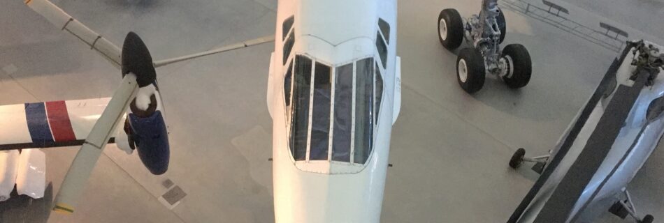
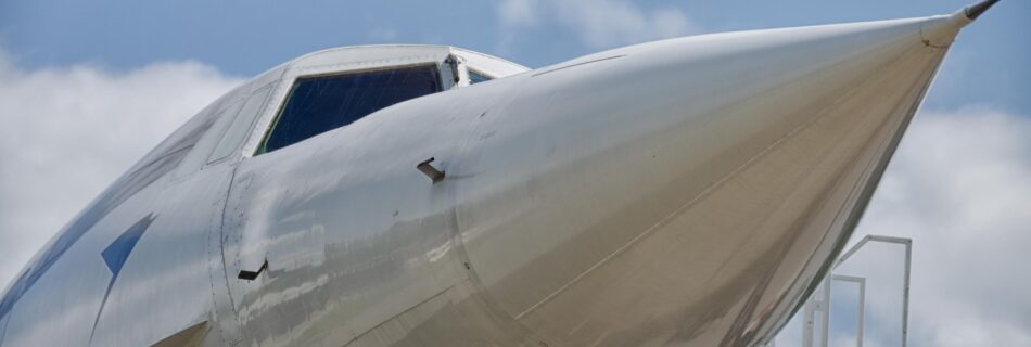
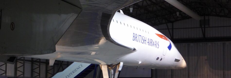
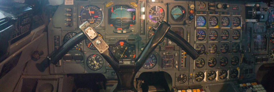
Categories
Aviation

I’m back… talking aviation films…

It’s been a long time, but I’m back adding a few more Kb to my hosting account, this first post of 2016, has little to do with the world of Geo but is all to do with my other passion aviation.

As is the trend in almost all forms of online journalism and blogging (not much difference these days you may say..) I present to you a list of my favourite aviation films for you to watch on Netflix, Amazon , NowTV etc..

So in no particular order ,

Top Gun (1986)

Of course, Top Gun had a significant impact on me as student, resulting in me wandering around college in a flying suit with genuine US Navy VF-84 crew patches – I was always keen on authentic details.
A best selling 80’s soundtrack, Tony Scotts high energy direction, US Naval aviation at its peak and Meg Ryan – how could you not like this..
Completely missed the the homoerotic subtext at the time !

The Battle of Britain (1969)

Edward Fox parachuting from his burning Spitfire into a greenhouse and been offered a cigarette by schoolboy, “Thanks awfully, old chap!” he responds, there is the perfect encapsulation of the Battle of Britain to the British psyche. Guy Hamilton’s film needs to be seen in the full 70mm Panavision version to really appreciate the aerial sequences of (mostly) actual Spitfire and Hurricanes dogfighting with admittedly Spanish built  Messerschmitts and Heinkels. Contrast these wonderful scenes with ludicrous dogfights of Pearl Harbour or Red Tails,  why has nobody managed to do a realistic dogfight using CGI ?

The Dambusters (1955)

Another film deeply ingrained in the British consciousness, this famous film tells the story of  Operation Chastise the bombing of German Dams in 1943. The film to be honest is not great from the perspective of wonderful aerial sequences instead it masterfully illustrates the development of mines by Barnes Wallis and the sacrifice of war experienced by crews of 617 Squadron.  Despite it’s position in popular culture this is quite a serious film that examines the effect of conflict on the people involved especially Barnes Wallace played perfectly by  Michael Redgrave.

Hells Angels (1930)

Howard Hughes epic of 1930 so of course rather dated to modern eyes full of melodrama and over acting but the aerial sequences filmed  using real WW1 surplus aircraft and pilots are extraordinary.  The scale of these sequences are amazing, 80+ aircraft in the air flying around the camera aircraft, just imagine the results using modern GoPros !

Strategic Air Command (1955)

The early years of the Cold War when the American Defence Budget seemed to have no limit, and Propaganda was produced at a similar scale.  Jimmy Stewart, a genuine 8th Air Force Bomber Pilot, does his bit playing a baseball player recalled to serve in the Air Force.
The storyline is nothing to write home about, and the contrast with “The Dambusters” released the same year is notable, but the real stars are 1950’s B-36 and B-47 Bombers.

The Bridges at Toko-Ri (1954)

The Korean War has not featured very much in cinema and this 1950’s version of Top Gun stands out because of this and because it’s actually quite a cool and serious film.. The film builds slowly and despite some light relief from Helicopter Pilot Mikey Rooney, it develops into grim war drama with an unusual ending !

Always (1989)

The polar opposite  of  “The Bridges of Toko-Ri”, this is a romantic Steven Spielberg movie with WWII firebombers! A pilot is killed on a firefighting mission and his ghost then has the task of getting his girlfriend together with a younger fire bomber pilot….
Well thank heavens for the glorious old and battered A-26, Catalina, C-119 and Bellancas .
A remake of the 1943 “A Guy Named Joe”, this should not work, but I have a soft spot for Holly Hunter and warbirds… so there you go!

Missing in Action ?

The film I would not watch might surprise you; 633 Squadron,  great music – terrible everything else, the use of Airfix models on wires is unforgivable !

Fellow aviation enthusiasts.. what have I missed ?


Categories
INSPIRE SDI

Making SDIs work !

Excuse my voice I had flown in the night before and I had a case of “airplace flu” and two hours sleep, nevertheless a reasonably coherent discussion of the future of Spatial Data Infrastructure development for the new Geobuiz channel.

Categories
Apple Thoughts

The next Steve Jobs – and then some!

Once the recognised industry visionary was without doubt Steve Jobs, the ultimate showman – the man who claimed to want put a dent in the universe by creating technology so well designed and well of course marketed that it’s introduction would change society.

Take for example..

  • Apple II
  • Apple Macintosh
  • Apple iPhone

Now without Jobs, Apple seems to be turning away from technology and becoming a fashion brand, producing so-so technology with added “bling” to appeal to celebrities, the evidence m’laud.. The new Macbook in Gold and the Apple Edition Watch.

Now as an Apple Fanboy that’s was a difficult point to make.

The new tech visionary I and others identify is Elon Musk CEO of Tesla and Space-X, who rather than just building consumer electronics is working on the slightly bigger challenges of carbon free transport/power generation and rocket science !

And he comes across as a straightforward humble guy, as demonstrated in yesterday’s launch of his domestic battery system – the Powerwall.

https://youtu.be/yKORsrlN-2k

If you have kids and you want to show them someone to admire as an alternative to Sports stars, celebrities or (unlikely) politicians show them this video, and read his Wikipedia entry.

Posted from the Dali Lounge, Barajas Airport, Madrid .


Categories
Aviation Blog Concorde Thoughts

10 years ago today at 50,000 feet !

At just after 9:00 am on the 29th May 2003, I achieved a lifetime ambition and flew  Concorde ! Concorde had six months of service remaining with British Airways so the rush was on for fellow Aviation geeks to organise the trip of a lifetime.

The journey was perhaps the last occasion that I could describe as an example of glamorous air travel. The dedicated Concorde lounge at JFK’s Terminal 7 had a real buzz about it, although the usual compliment of banker and celebrity passengers was supplemented my people such as myself who were here for the ride..

IMG_0037.JPG


Clearly visible through the wall to celling windows was the flagship of British Airways fleet, G-BOAC. After the obligatory glass of champagne it was time to board and I took my seat 6D inside as everyone says the rather cramped cabin, similar to a modern Embraer E jet .

I had specifically chosen to fly back from New York to London on flight BA002 as my Concorde experience for what happened next.. Anyone who flew on Concorde will tell you the take off was like no other experience  after all it was the only commercial airliner to take off using afterburners ! But the take off from New York was even more special, because of the need to carry out noise abatement procedures very quickly after take off, Concorde made a hard left turn, enough to make you feel both pushed down and back into your seat from the acceleration – very roller-coaster like !

This video give you some sense of this unique departure..


Very quickly after take off the afterburners are switched off and there is a noticeable deceleration and reduction in noise. After a few minutes and another glass of Champagne and canapés, it was time to really get going.. the Captain made a short announcement switched on the afterburners again which felt like a kick in the back  and we rapidly accelerated to Mach 2.0 1330 MPH and an altitude of 56,000 feet.

IMG_0058.JPG


At such a speed and altitude there was no real impression of speed, other than perhaps from the heat felt when touching the small windows, the heat a product of air friction.

IMG_0048.JPG

Looking out of the window produced a view quite different to the 747 flying only half as high as Concorde. The sky was much darker and it is possible to just about see the curvature of the earth, and the thin blue line which represents the vital but very fragile part of the atmosphere in which we all live.

IMG_0056.JPG

I will never in all likelihood be as high or travel as fast again in my life as I did for those couple of hours ten years ago,  indeed the captain made the point at that moment there were only five people higher than the 100 passengers in Concorde, and they were on the International Space Station !

I completely understand the economics of why Concorde no longer flies, but is still seems wrong that the technological masterpiece on which  I flew now sits in a Museum at Manchester Airport !

Written and submitted from home (51.425N, 0.331W)


Categories
INSPIRE Thoughts

Inspire a moonshot not a blueprint ?

A few weeks ago I had the pleasure to take part in the ImaGIne conference organised by the European Umbrella Organisation for Geographic Information in Dublin. The conference although not very well attended did contain both excellent presentations and perhaps unusually great discussions which really seemed to address some of the key challenges of using geospatial technology in Europe.

A talk on the use of Geo in the context of Europe brings us inevitably to the Inspire Directive and it’s progress and impact. Inspire which came into force almost exactly six years ago is the programme to build an European Spatial Data Infrastructure by October 2020.  Inspire was the topic of much discussion at the conference as this year a number of important articles of the directive must be implemented.

An obvious concern expressed by many, included myself, is the difficulty of legislating to build an information system over such a long time.  Developing quite prescriptive  rules as to how to share information is almost impossible with the speed of technological development online.

The issue is perhaps more problematic when you think that many of the ideas and principles enshrined in the Directive were developed during the five years leading up to 2007, a time before social networking, big data and the mobile internet.

In hindsight of course perhaps a less rigid approach which articulated the principles of sharing environmental data and their benefits might have been a better outcome, concentrating on policy issues around reuse of information rather than the actual mechanics. And yes of course I accept the point that without harmonisation of data and the creation of (limited) metadata data sharing is difficult, nether-less often inspirational ideas are best when they plant the seed of an idea and accept that how the idea is accomplished may differ.

Before the conference in Dublin, I was asked to speak at a meeting at the European Commission in Brussels and was asked to bring along a object which to me represented the Inspire programme. Feel free to suggest your own in the comments, but I brought along my rather battered copy of Jules Verne’s “From the Earth to the Moon“.

Along with HG Wells, Verne is credited with pioneering science fiction, and with this book although published in 1865  demonstrates the power of a inspiration idea. Both Wernher von Braun and Robert H. Goddard cite the book as a catalyst for their interest is rocketry and space exploration. Published 100 years before the actual moon landings Verne was able to make some uncanny predictions, correctly suggesting that three men would leave the earth in a capsule launched from Florida after much political horse trading!  Of course technology moved on and 1969’s great achievement was made with liquid fuel rockets and computers not the large cannon suggested by Verne – still the idea was the inspiration !

So perhaps we should look at the Inspire programme in the same way, a moon shot idea that today may be achieved is different ways to at first considered..

Written and submitted from home (51.425N, 0.331W)


Categories
Aviation Google Earth

When a map tells a story..

Last weeks tragic accident involving the crash of a Augusta helicopter in London, which claimed two lives is still fresh in the minds of most Londoners. Yesterday the Air Accident Investigation Branch (AAIB) published their initial accident bulletin, which describes the facts surrounding the accident as investigated without the analysis which will come in a later report in some months time.

The AAIB report illustrates the last few minutes of the flight of the helicopter using this graphic produced with Google Earth.


G-CRST track

The track data comes from the reported radar position and Mode S altitude data produced by the helicopters transponder. The helicopter an AW 109E G-CRST was flying south after attempting to land at Elstree, and from the track you can was flying east while waiting for clearance to land at the London Heliport in Battersea a few miles to the west. According to the AAIB report at 0759 clearance was received at the helicopter began a turn to the south to head back west towards Battersea.

G-CRST at Fairoaks (image flickr: billy_mcnally)

In the turn the helicopter hit the crane on top of the St. Georges Wharf development, shedding it’s rotor blades and crashing to the ground on Wandsworth Road.

While the graphic above is itself powerful of course it does not tell the full story, a key contributing factor to this accident will be the weather conditions at the time of low cloud and freezing fog with a cloud base lower than the 700ft high crane.

Written and submitted from home (51.425N, 0.331W)

Categories
Apple Thoughts

Bad maps.. really a search problem

So now everyone knows making a map of our little planet to make available to users of mobile devices everywhere that is both accurate, up-to-date and detailed is hard. And with the benefit of hindsight and industry expertise we can smile knowledgeably at the mainstream tech press falling over themselves debating and theorising over Apple Mapgate !

But are we all missing the point, I have seen very few comments in the specialist or mainstream tech press that really address the true issue here.. Making maps work well on a phone is not actually a cartography problem.. yes you can use poor maps or conflate content from various sources without care producing a poor map, and people might get lost… but the reason we all use maps on our phones is that they help us find stuff – maps on smartphones are interfaces to local search.

Local search has all the issues of web search plus the added complication of needing to explicitly locate relevant information in relation to the location of the user.. To be successful you need a geocoded search index of places, an algorithm to identify terms that relate to places and of course some maps to put it all in context.

To be fair to our friends in Cupertino the maps are not that bad, all maps have some mistakes, but the bigger issue is the lack of a true geocoded search index of places and the search algorithms that sit around it.

Local search is in many ways what makes smart phones smart, because the users location and the location of things around them provides a set of contextual pointers to relevant information. If you are a lucky owner of a Jelly Bean powered android smartphone have a used Google Now, just think about how many of the information cards are related to location.. weather, travel information etc.

To make good maps that are globally consistent, accurate and up-to-date is hard and takes lots of people as well as clever software, as it is a business of relationships with many different providers of local data, and potentially local community groups. Transit directions are a case in point, they are not difficult to do technically, but the number of organisations that you must partner with to obtain data runs into the thousands   – it really does take years..

To understand local search is much harder you need the maps from above, plus the ability to crawl, create, maintain and understand a geo search index, and to query it in ways that provide value to you end users – that takes decades…

Maps on smartphones are so powerful and useful because they are far more than a digital version of an A-Z street atlas.

Written and submitted from home (51.425N, 0.331W)


Categories
Blog

My Wife and Daughter rowing 80 miles for charity

My Wifeand Daughter rowing 80 miles for charity..

And next weekend you find me somewhere on the riverbank of the Thames between Oxford and Hampton Court!

Flo Blake Parsons is fundraising for KGS FOUNDATION
Categories
GPS

Maposaurus how did I miss you !

I can’t believe I had not come across this video before, from a 2007 Superbowl advert from Garmin, the Maposaurus !

Happy Friday everyone !!

Written and submitted from the Google Offices, London (51.495N, 0.146W)

Categories
Data Policy

NRE App – just wrong !

Today National Rail Enquires have released a free iPhone app for real time train information. Hang-on you may say, I though that app already existed.. well it does !

For the last few years National Rail Enquires (NRE)  have been licensing at some considerable cost it’s information to independent software developers for them to develop their own apps, indeed one of my favourite all time apps is UK Train Times developed by Dave Addey and his team at Agant.

Todays release is clearly a case of channel conflict by a Quasi-Government organisation, and I would suggest anti-competitive.

NRE should not be developing an app and competing with it’s “partners” who have developed a range of apps for the last few years. NRE should just release the data under an Open Gov Licence and let the ecosystem develop !

So much for the release of government data empowering the software industry, my old friends at Ordnance Survey always recognised this was an issue and kept out of their partners space, not developing a mobile OS maps application despite what I might have argued at the time 🙂

Written and submitted from home (51.425N, 0.331W)