A short section this, as expected getting to and from the start and end points on public transport took almost as much time as walking the route. The first section from Uxbridge continued North along the banks of the Grand Central Canal although this is a beautiful rural section all the way.
Grand Union Canal at Harefield
At Harefield West the route turns right and finally starts heading East, the route leaving the Canal and passing through some proper countryside and woodlands.. this is proper country walking with the first stile of my walk !
The first Stile !
There is nice contrast on this section with open countryside and then the quite dense woodland of Bishops Wood
Bishops Wood
It’s in the woodland than the need for a map and some basic navigation skills become obvious, spot the direction marker in the picture below.. Miss it and you are heading off in the wrong direction !
Look very carefully the direction sign is at the centre of this image..
Just before entering the wood I came accross the walk’s most interesting / unexpected sight… I pointed out the route was heading East but I did not expect to see a Chinese Police Car parked on a farm track!
The London Loop Part 1 : Teddington to Hatton Cross
Time for another quest, the scope limited in the current COVID-19 world, so no Globe Trotting hunting Concorde, instead a longish walk.
I have been walking a lot since COVID has become part of our lives, usually in the evening around the neighbourhood, my Fitbit tells me that since March that’s an average of 21,000 steps per day !
Much as I love this part of South West London, I wanted a challenge and was vaguely away of the London Loop, a walking route around London of some 150 Miles ( 242 km) which happens to pass through Bushy Park very close to my home in Teddington.
The only real question was which way… Clockwise of course!
The Beginning and hopefully the end – Chestnut Avenue, Bushy Park
The route is signed although not very well in places and although the trusty OS Explorer map can be vague in places, it really is required – it may not be hiking up Snowdon but without one you will get lost !
1:25,000 Ordnance Survey – Old School but very necessary!
Today was Part 1 an easy 10 miles or so from the starting line of the Chestnut Avenue in Bushy Park, following the River Crane to Hatton Cross close to Heathrow Airport, actually remarkably rural as you case see from the pictures below..
Interesting sight on this part of the route is the Shot Tower in Crane Park, built in 1826 to manufacture lead shot.
Crane Park Shot Tower
Essentially a lighthouse with a heating chamber rather than a light at the top. Lead was heated until molten, then poured through a copper sieve. The size of the shot determined by the size of the holes in the sieve. As the drops of molten lead fell through the air surface tension formed them into spherical balls. At the bottom of the tower the lead shot was caught in a water-filled basin.
Bloomberg reports the latest rumours surrounding the upcoming iPhone launch, including such Geo technologies as LIDAR expected to feature in at least some of the new devices this Autumn.
The extent to which such previously specialised and complex technologies are reaching the mass market should not come as a surprise, after-all GPS receivers were once very specialised. As soon as a consumer value was identified however, mass market production and simplification reduced the price of these features considerably, and today they provide much of the smart in smartphones!
However the most interesting part of the report for me is almost a footnote, Apple will introduce a “Find my Remote” capability to the next generation Apple TV.
In the crazy days of Where 2.0 and the maximum inflection point for Location Based Services (LBS) we used to quote that one of the most common phases uttered on phone calls was “Where are you?”, thus we argued there was a huge opportunity for friend finding applications – well that did not quite work out, however when did you last ask at home… “Where is the TV remote?” while searching under the sofa cushions…
Where is the TV remote ?
Unlike friend finding there are no privacy implications of finding your own stuff in your own home.
This is a perfect example of Ambient Location working at the personal scale, the application of traditional geospatial technology over the range of a few metres often having the users own location as the origin of a local private coordinate system.
It may be argued that we are still only in the early days of the “Internet of Things” where the networked devices we own at home (or work – is there a difference these days?) both provide relevant information to us and modify their behaviour based on both environmental factors and the proximity of people to them.
I get the feeling I’m still very much the “early adopter” with my Nest smoke detectors sensing when nobody is at home to switch off the heating or having my Hue controlled lights automatically turn on when my video door bell recognises I’m returning home..
This is all still rather complex to set up and, if I’m honest, rather flakey in operation..
But… there is another innovation which the “Find my Remote” use case also demonstrates that may make this all much more mainstream.
Coming to a surface near you soon…
Surface computing is another term beloved by technologists which covers the development of voice based assistants and other personal technology such as home electronic displays which are becoming alternative “surfaces” which we use to interact with the internet and with cloud based services.
“Alexa, re-order AA batteries”, “Hey Google, Join my meeting”, and soon “Siri, where is my remote” are phrases becoming common in our homes and make use of the surface interfaces to home automation services – and of course many of these surfaces rely on an explicit knowledge of location, at least within the logical framework of our homes.
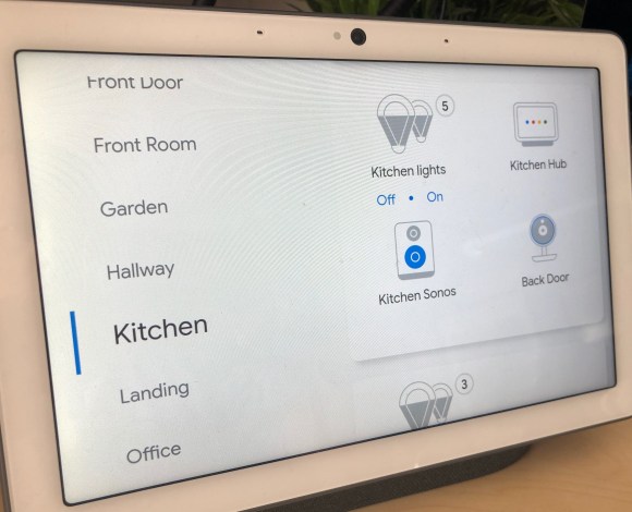
If I’m in the Kitchen, I just have to ask to “Switch on the lights”, there is an explicit knowledge that since the Home Hub in the kitchen picked up my voice, the lights I’m requesting switched on are those in the kitchen..
The logical map of my home?
This understanding of our homes from a spatial perspective is still rather limited, we don’t for example usually have an understanding of the topological connections between rooms but that will come… perhaps from devices equipped with LIDAR!
The “Parsons Test” of IoT ?
In the past I have offered the simple use case of
“Hello Computer, are my keys upstairs?”
as a test case for demonstrating a useful application of combined IoT / surface computing, seems we are getting close to passing the test.
When you expect a surface computing interface…
Of course we could just eliminate the need for keys or remote controls in the first place ;-